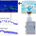
© Archiv Vogelwarte
Radar ornithology
Radar is the only technology which allows recording bird migration continuously over long time periods and across all height intervals during day and night. The Swiss Ornithological Institute has been investigating bird migration by radar for more than 40 years. Various studies have been carried out in Europe, the Near East and the Africa. Apart from basic research, studies with respect to environmental impact assessments have been an important part of the work (e.g. impact of wind farms, tall buildings, etc.).
Aims
Our radar studies aim at:
- investigating the environmental influence on the temporal and spatial distribution of bird migration
- examining the environmental influence on individual flight behaviour
- modelling and forecasting the temporal and spatial phenology of bird migration
- improving radar systems for automatic real-time recording and analysis of bird migration
- improving software for automatic classification and identification of different species or groups of species (e.g. passerines, waterfowl).
Approach
The airspace is being used by a large variety of avian and non-avian species. Therefore, differentiating between birds and non-bird echoes (e.g. insects, rain, ground clutter) is essential. We monitor bird movements at specific locations with radar systems specifically developed to record and identify birds (BirdScan MR1).
These systems allow . . .
- a continuous quantitative compilation of height distributions
- the recording of flight directions and flight speeds
- the identification of different groups of birds based on their wing-beat patterns
Within an international cooperation we could show that weather radars can be well suited to provide highly valuable information on bird migration. As a follow-up, we now cooperate within the European network of Radar Animal Monitoring (ENRAM) with colleagues from all around the world to make use of the European network of weather radars for a large-scale monitoring of bird movements across the European continent.
Significance
Quantifying the spatially and temporally explicit patterns of bird movements is a prerequisite to understand environmental impacts on the continent-wide migration. Only a continuous and automatic monitoring of migration by radar allows systematically recording also the rare but very specific events of mass movements, which often are only mentioned as anecdotes. Modelling and forecasting bird movements are not only important for basic research, but are also highly welcome for avoiding collision in military and civil aviation as well as at tall man-made constructions.
Results
- Influence of topographical structures (mountain ranges, sea, desert) on migratory behaviour of trans-Sahara migrants
- Height distributions of migrants in relation to atmospheric conditions (wind etc.)
- Validation of weather radar systems for quantifying nocturnal bird migration
- Validation of capture numbers (bird ringing) in relation to migratory intensity
- Potential hazard for migratory birds by wind turbines and other tall buildings
- Composition of nocturnal bird migration (passerines, waterfowl)
- Flight speed, air speed and wing-beat patterns of wild birds
Project management
Felix Liechti, Janine Aschwanden, Thomas Steuri, Baptiste Schmid
Partners
- Prof. Bruno Bruderer
- ENRAM – European Network for Radar surveillance of Animal Movements
- Swiss Birdradar Solution AG
- Jason Chapman - University of Exeter (GB)
- Andrew Farnsworth – Cornell lab for ornithology
- Daniel Früh – ZHAW
- Volker Roth and Heiko Schuldt - University of Basel
- E-life
Financial support
SNF – Swiss National science Foundation
Publications
Barrier effects of mountain ranges for broad‑front bird migration.
Simulation of broad front bird migration across Western Europe.
The grand challenges of migration ecology that radar aeroecology can help answer
Cross‐calibration of different radar systems for monitoring nocturnal bird migration across Europe and the Near East
A Geostatistical Approach to Estimate High Resolution Nocturnal Bird Migration Densities from a Weather Radar Network
Size matters in quantitative radar monitoring of animal migration: estimating monitored volume from wingbeat frequency
Temporal and spatial distribution, and flight directions of migratory birds in Tsavo West National Park, Kenya: a comparison of radar and ringing data.
Consistency of spatio-temporal patterns of avian migration across the Swiss lowlands.
Bird collisions at wind turbines in a mountainous area related to bird movement intensities measured by radar.
Complex behaviour in complex terrain - Modelling bird migration in a high resolution wind field across mountainous terrain to simulate observed patterns.
Vertical distribution of bird migration between the Baltic Sea and the Sahara.
Field validation of radar systems for monitoring bird migration.
Aeroecological Observation Methods.
Vogelzug - Eine schweizerische Perspektive.
Aeroecology.
Facing the Wind: The Aeroecology of Vertebrate Migrants.
Comparison of visual bird migration counts with radar estimates.
Atmospheric conditions create freeways, detours and tailbacks for migrating birds.
The gliding speed of migrating birds: slow and safe or fast and risky?
Continental-scale radar monitoring of the aerial movements of animals.
Modelling the spatial concentrations of bird migration to assess conflicts with wind turbines.
Vom militärischen Zielfolgeradar zum Vogelradar.
Orientation of passerine trans-Sahara migrants: the directional shift ('Zugknick') reconsidered for free-flying birds.
How do diurnal long-distance migrants select flight altitude in relation to wind?
Multi-generational long-distance migration of insects: studying the painted lady butterfly in the Western Palaearctic.
Wing-beat characteristics of birds recorded with tracking radar and cine camera.
Do bird captures reflect migration intensity? Trapping numbers on an Alpine pass compared with radar counts.
Adjustments of wingbeat frequency and air speed to air density in free-flying migratory birds.
Trans-Sahara migrants select flight altitudes to minimize energy costs rather than water loss.